 |
|
 |
|
|
|
|
|
|
|
|
|
|
|
|
|
|
|
|
|
|
|
|
|
|
|
|
|
Altitude |
|
Length of perpendicular from vertex to base. Height above mean sea-level. |
|
Archipelago |
|
Sea with many islands; group of islands. |
|
Astrobleme |
|
Crater that was created by a meteor impact. |
|
Bank |
|
Raised shelf of ground; artificial slope. / Ground at edge of river. |
|
Barren |
|
Barren land; elevated plains on which grow small trees and shrubs, but no timber. |
|
Basin |
|
Hollow depression; circular or oval valley. |
|
Bay |
|
Part of sea filling wide-mouthed opening of land. |
|
Caldera |
|
A large, more or less circular depression or basin associated with a volcanic vent. Its diameter is many times greater than that of the included vents. Calderas are believed to result from subsidence or collapse and may or may not be related to explosive eruptions. Calderas are large volcanic depressions, roughly circular in shape, from 1 to 250 km in diameter. Structures less than 1 km diameter are termed maars, and those over 250 km volcanic depressions. |
|
Canyon / Cañon |
|
Deep gorge or ravine with steep sides formed by river cutting through soft rock. |
|
Cay |
|
Low insular bank or reef of sand, rocks, etc., esp. off coast of Spanish America. |
|
Channel |
|
Natural or artificial bed of running water; comparatively narrow piece of water joining two large pieces. |
|
Cinder Volcanic ash |
|
Slag; résidue of coal, wood, etc. that has ceased to flame but has still combustible matter in it; (pl.) ashes / A fragment of volcanic ejecta from 0.5 to 2.5 cm in diameter. Cinder cone (Cône de scories): A cone-shaped hill composed of loose volcanic fragments. A cinder cone is formed by explosive eruption or lava fountain. It is composed of mostly loose material. The cone may be beautifully symmetrical with slopes of 30-40 deg, and height of several several hundred metres. The diameter can be several km. A cinder cone is composed of material ranging in size from 4 to 32 mm (lapilli or little stones). Volcanic ash: Dust-size particles ejected from a volcano. |
|
City |
|
Important town (England) / Town of greater importance, or size, or whith wider municipal powers, than those called simply 'towns' (U.S.). |
|
Coast |
|
Sail along coast, trade between ports on same coast. |
|
Cone |
|
Solid figure or body of which the base is a circle (or other curved figure) and the summit a point, and every point in the intervening surface is in a straight line between the vertex and the circumference of the base; any conical mass. Cone: A volcanic cone is a conical hill built from tephra and lava. |
|
Continent |
|
One of the main continuous bodies of land on earth's surface. |
|
Convergent plate boundary |
|
The zone where the leading edges of converging plates meet. Convergent plate boundaries are sites of considerable geologic activity and are characterized by volcanism, earthquakes, and crustal deformation. |
|
Cordillera |
|
One of series of parallel mountain ridges or chains. |
|
Country |
|
Region; territory of nation. |
|
Crater |
|
Bowl- or funnel- shaped hollow at top or side of volcano from which eruption takes place; bowl-shaped cavity, esp. that formed by exploding shell, bomb or by the impact of a meteorite. Crater Row: Isolated lava fountains along a fissure produce crater rows of small spatter. Explosion Crater: Explosion crater is a large circular, elongate, or horseshoe-shaped excavation with ejected debris on its rim or flanks. |
|
Current |
|
Running stream; water, air, etc., moving in given direction. |
|
Delta |
|
Triangular tract of sand, gravel , and silt enclosed and traversed by the diverging mouths of a river. |
|
Depth |
|
Being deep; measurement from top down, from front to back, or from surface inwards. |
|
Divergent plate boundary |
|
A plate margin formed where the lithosphere splits into plates that drift apart from one another. Divergent plate boundaries are areas subject to tension, where new crust is generated by igneous activity. |
|
Dome |
|
Rounded summit of hill etc. (structural geology) An uplift that is circular or elliptical in map view, with beds dipping away in all directions from a central area. (topography) A general term for any dome-shaped landform. |
|
Earthquake (Seism, seismic event) |
|
Convulsion of earth's surface caused by volcanic activity or faults in the earth's crust. HAMBLIN, W. Kenneth. The Earth's Dynamic Systems. 1989. The point within the Earth where the initial slippage generates earthquake energy is called the focus. The point on the Earth's surface directly above the focus is called the epicenter. Shallow-focus earthquakes occur from the surface to a depth of 70 km. They occur in all seismic belts and produce the largest percentage of earthquakes. Intermediate-focus earthquakes occur between 70 and 300 km below the surface. Generally, they are confined to convergent plate margins. Deep-focus earthquakes occur between 300 and 700 km. Generally, they are confined to convergent plate margins. The intensity, or destructive power, of an earthquake is an evaluation of the severity of ground motion at a given location. It is measured in relation to the effects of the eartquake on human life. Scale of Earthquake Intensity (Mercalli from 1 to 12):
The magnitude of an earthquake is a measure of the amount of energy released. It is a much more precise measure than intensity. Earthquake magnitudes are based on direct measurements of the size (amplitude) of seismic waves, made with recording instruments. Seismologists express magnitudes of earthquakes using the Richter scale (from 0 to 10). Each step on the scale represents an increase in amplitude by a factor of 10. If A = 1 µm and if d = 100 km, by definition M = 1. According to Richter: The relation between the amplitude of the ground motions (Ag) and the amplitude of the seismogram path (At) is: Ag = At/K ; K = instrument amplification, Ag in µm and At in mm. If the seismograph is not at 100 km from the epicenter: M = log (A/T) + f(d). A= instrument amplitude, T = period in seconds, d = distance in degrees. According to Nuttli: Mb(Lg) = -0,10 + 1,66 log d + log (A/T). A = maximal amplitude, in µm, of the seismic wave, T = wave period, in seconds, d = distance of the epicenter, in km. This equation is valid if d is between 450 and 3 000 km and if T < or = 1,3 second. There is a narrow relation between magnitude and energy released by a seism. log E = 4,8 + 1,5 ; E = energy in joules and M = magnitude |
|
East |
|
Point of horizon where sun rises at equinox; this direction. / Cardinal point of the compass 90o to the right of north. |
|
Equator |
|
Great circle of the earth equidistant from poles. |
|
Fault |
|
Flaw in ice; place where rock-layers have fractured and moved out of alignment. Transform Fault (Failles transformantes): A special type of strike-slip fault forming the boundary between two moving lithospheric plates, usually along an offset segment of the oceanic ridge. |
|
Fumarole |
|
Hole in earth's crust through which gases and vapour issue. Fumarole Field: Fumarole fields, and solfatara fields, areas of hot springs and gas vents where magma or still-hot igneous rocks at shallow depth are leaking gases or interacting with the groundwater system. |
|
Glacier |
|
Slowly moving mass or river of ice in high mountain valley formed by accumulation and gradual consolidation of snow on higher ground. |
|
Gulf |
|
Portion of sea partially enclosed by sweep of coast, and usu. narrower at mouth than bay. |
|
Harbour |
|
Place of shelter for ships, esp. where they may lie close to and sheltered by shore, piers, etc. |
|
Highlands |
|
Mountainous or elevated country. |
|
Hotspot |
|
The expression at the Earth's surface of a mantle plume, or column of hot, buoyant rock rising in the mantle beneath a lithospheric plate. |
|
Hydrothermal Submarine Hot Spring Black Smoker |
|
Hot water circulations linked to the end of an volcanic eruption, or at the magma crystallisation, and to springs that can come eventually. |
|
Ice Field Ice Shelf |
|
Ice-Field: Extensive sheet of floating ice. Ice-Floe: Flattish free mass of floating ice, smaller than an ice-field Ice Shelf: Plate-forme de glace flottante; Ice-pack, pack, sea ice |
|
Inlet |
|
Small arm of sea, creek. |
|
Island |
|
Piece of land surrounded by water; (formerly) peninsula. |
|
Island Arc |
|
A chain of volcanic islands. Island arcs are generally convex toward the open ocean. |
|
Isthmus |
|
Narrow portion of land connecting two larger bodies of land, neck of land. |
|
Lagoon |
|
Shallow stretch of salt water partly or wholly separated from sea by narrow strip of land or low sand-bank or coral reef; enclosed water of atoll. |
|
Lake |
|
Large body of water entirely surrounded by land. |
|
Land |
|
Solid part of earth's surface; expanse of country; country, State. |
|
Lava |
|
Molten rock (magma) which flows down sides of volano; solid substance this cools into. Lava Cone: A volcanic cone composed primarily of lava flows is called a lava cone. Sometimes the cone can contain a convex profile due to flank flows of viscous lava. Lava Domes: Landforms of this sort consist of steep domal mounds of lava so viscous that the lava piles up over its vent without flowing away. The rock types that form lava domes are generally andesites, dacites, or rhyolites. Somehow these viscous lavas have lost much of their gas content in prior eruptions or by slow rise to the surface. Even so, it is not unusual for an actively growing lava dome to have an explosive eruption that disrupts all or part of the dome. Many lava domes grow by internal intrusion of lava that causes swelling and oversteepening of the dome. Rockslides build up an apron of talus blocks around the lower sides of the dome. Lava domes can form mounds several hundred metres high and from several hundred to more than 1,000 metres in diameter. Thick lava flows sometimes move short distances from the dome and distort its generally circular or oval shape. Currently domes are forming at Merapi, Mt St Helens, and Montserrat as well as others. |
|
Limit |
|
Bounding line, terminal point, bound that may not or cannot be passed (ice). |
|
Lithospheric (tectonic) Plate |
|
A broad segment of the lithosphere (including the rigid upper mantle, plus oceanic and continental crust) that floats on the under-lying asthenosphere and moves independently of other plates. |
|
Maar |
|
A maar is a low-relief, broad volcanic crater formed by shallow explosive eruptions. The explosions are usually caused by the heating and boiling of groundwater when magma invades the groundwater table. Maars often fill with water to form a lake. A maar is a type of tuff ring which has been affected by sagging so that it lies below the the level of the surrounding surface. A maar is often filled with water and surrounded by a rim of ejected material that was probably formed by explosive interaction of magma and groundwater. |
|
Massif |
|
Mountain heights forming compact group. |
|
Meteorite |
|
Fallen meteor, fragment of rock or nickel iron which has fallen from space on to earth's surface. Asteroid: Any of the small planets revolving round sun mainly between orbits of Mars and Jupiter. According to Science et vie N° 1006, juillet 2001, Astéroïdes - La menace se précise... d'Hervé Poirier et all., p. 52-69, consequences of the meteor impact on Earth could be: * An asteroid of 75 m, that could form a crater of 1,7 km on Earth, could destroy Paris and kill 5 000 people. --> Sniff! Sniff! * An asteroid of 350 m, that could form a crater of 6 km on Earth, could destroy the French Island and kill 500 000 people. --> If sea impact, tsunamis in the oceans * An asteroid of 700 m, that could form a crater of 12 km on Earth, could destroy France and kill 1,5 billion people. --> Tsunamis across the World * An asteroid of 1,7 km, that could form a crater of 30 km on Earth, could destroy France, and kill 1,5 billion people. --> Dusts scattering that could change the earth's climate. Complete destruction of the ozone layer. * An asteroid of 3 km, that could form a crater of 60 km on Earth, could destroy France and some countries around France, and kill 1,5 billion people. --> Complete change of the climate. Huge Fires because of the matter ejection. * An asteroid of 7 km, that could form a crater of 125 km on Earth, could destroy Europe and kill 3 billion people. --> Extend Effects on the climate. Probable masses extinction. * An asteroid of 16 km, that could form a crater of 200 km on Earth, could destroy the World and kill 6 billion people. --> Masses extinction like Cretaceous extinction (90 % species eliminated of the Earth) See the Plates tectonic map to see the similar impacts that happened in the past. |
|
Monsoon |
|
Seasonal wind prevailing in southern Asia, from south-west (wet monsoon) in summer and north-east (dry monsoon); rainy season accompanying South West monsoon. |
|
Mountain |
|
Natural elevation of earth's surface of impressive height, esp. over 1 000 ft. |
|
Mouth of River |
|
Opening or entrance of anything; outfall of river. |
|
North |
|
Point of horizon to the left of an observer who faces the rising sun at the equinox; this direction. / Cardinal point of the compass 90o to the left of east and 90o to the right of west. |
|
Ocean |
|
Great body of water surrounding the land of the globe; one of the main areas into which this is geographically divided. |
|
Oceanic Trough Graben |
|
Trough = Long narrow open box-like wooden. Hollow or valley resembling trough. Fosse d'effondrement = Graben, Rift valley, Taphrogenic trough Fosse tectonique = Graben, Fault trough Trough = Dépression, Axe synclinal, Gouttière synclinal Trough valley = Vallée en auge, Vallée synclinale Fault trough = Fossé tectonique Oceanic trough = Fosse océanique Rift = Cleft, fissure, chasm, in earth or rock. / Rift valley, valley with steep parallel walls, formed by subsidence of earth's crust. Rift = Grande faille à décrochement horizontal. / Crevasse, fissure Rift trough = Fossé tectonique, graben Rift valley = Fossé central de la crête |
|
Passage |
|
Passing, transit. |
|
Peninsula |
|
Piece of land almost surrounded by water, or projecting far into the sea. |
|
Plain |
|
Level tract of country. |
|
Pumice |
|
Very light porous stone formed by the solidified froth on the surface of glassy lava, used, freq, powdered, for polishing and abrading. Pumice Cones: A pumice cone is a structure similar to a cinder cone but made up of volcanic glass fragments so filled with gas-bubble holes that it resembles a sponge and is very lightweight; pyroclastic cone, a cone-shaped volcano composed almost entirely of pyroclastic material. |
|
Pyroclastic |
|
Pertaining to fragmental rock material formed by volcanic explosions. Pyroclastic texture (Texture pyroclastique): The rock texture of igneous rocks consisting of fragments of ash, rock, and glass produced by volcanic explosions. Pyroclastic Cone: Volcanic cone composed of material ejected from the volcano. The material can range from the finest particles to large bombs. In comparison, cinder cones are more uniform. Pyroclasts are also called tephra. Pyroclastic Shield |
|
|
|
|
|
|
|
|
|
Plate tectonics |
|
The theory of global dynamics in which the lithosphere is believed to be broken into individual plates that move in response to convection in the upper mantle. The margins of the plates are sites of considerable geologic activity. |
|
Plateau |
|
Elevated tract of comparatively flat or level land, table-land. |
|
Polar Circle |
|
Arctic or Antarctic Circle, at distance of 23o28' from the poles. |
|
Ridge |
|
Line of junction in which two sloping surfaces meet; any narrow elevation across surface; long narrow hill-top, mountain range, watershed. Oceanic Ridge (Dorsale océanique): The continuous ridge, or broad, fractured topographic swell, that extends through the central part of the Arctic, Atlantic, Indian, and South Pacific oceans. It is several hundred kilometers wide, and its elevation above the ocean flooor is 600 m or more. |
|
Rift |
|
Cleft, fissure, chasm, in earth or rock. Rift system: A system of faults resulting from extension. Rift valley: Valley with steep parallel walls, formed by subsidence of earth's crust. |
|
Rise |
|
Ascent, upward slope; knoll, hill. |
|
River |
|
Copious stream of water flowing in channel to sea, lake, marsh, or another river; copious flow of stream of. |
|
Scarp (Seascarp) |
|
Any steep slope (sea). |
|
Scoria |
|
Cellular lava, fragments of this; slag. An igneous rock containing abundant vesicles. |
|
Sea |
|
Continuous body of salt water covering most of earth's surface. |
|
Seamount |
|
Mountain, hill. |
|
Seismic Gap |
|
Areas along plate margins that are not seismically active are believed to be building up stress and may be sites of significant seismic activity in the future. No large quakes have occured and strain is still building up. |
|
Shield |
|
Extensive platform of primitive rocks. |
|
South |
|
Point of horizon directly opposite north; this direction. / Cardinal point of the compass opposite north. |
|
Southern Northern |
|
Of the South. Of the North. |
|
Spring |
|
Place where water, oil, etc. wells up from underground rocks; flow of water etc. rising from earth. |
|
Strait |
|
Narrow passage of water connecting two seas or large bodies of water. |
|
Stratovolcano / Composite volcano |
|
A volcano built up of alternating layers of ash and lava flows. Composite volcano (Strato-volcan): A large volcanic cone built by extrusion of alternating layers of ash and lava. Stratovolcanoes are the most common type of volcano. They account for 60% of all volcanoes. These volcanoes typically have the steep conical form that most people associate with a volcano. A stratovolcano consists of explosively erupted cinders and ash mixed with lava flows. It forms from a central conduit. The upper part is usually very steep (35 degrees) and contains loose rock. It may be almost impossible to climb safely on these steep slopes. Loose ash and cinders can make progress extremely difficult with one step up and two steps down marking the progress up the slope. There is also the danger of rockfall in the unstable environment. |
|
Subduction Zone |
|
An elongate zone in which one lithospheric plate descends beneath another. A subduction zone is typically marked by an oceanic trench, lines of volcanoes, and crustal deformation associated with mountain building. |
|
Swamp |
|
Piece of wet spongy ground, marsh. |
|
Terrace |
|
Horizontal shelf or beach bordering river, lake, or sea. |
|
Trench |
|
Trench = Long narrow usu. deep hollow cut out of ground. Fosse = Hole, Pit Fosse océanique = Trench, Deep Fosse sédimentaire = Basin Fosse topographique = Depression, Hollow Trench = Fosse sous-marine, Fosse de subduction |
|
Tropic |
|
Each of 2 circles of celestial sphere (northern: tropic of Cancer, and southern: Tropic of Capricorn) parallel to equator and 23o28' north and south of it, where sun reaches its greatest declination north or south; each of two corresponding parallels of latitude on earth's surface. |
|
Tuff |
|
Fine-grained rock formed from volcanic ashes. Tuff cone = Cône de cendres, cinérite. Tuff cones are less common than cinder cones. They are formed by magma-water eruptions (phreatomagmatic eruptions). They have steep sides (>25 degrees), and crater floors which lie above ground level. Surtseyan eruptions construct tuff cones when continuous supplies of large quantities of water enter into contact with rising magma. Their formation requires a more abundant water supply, and explosions at greater depths than those needed to build tuff rings. The resulting cones are often 100 m to 300 m high and 1 to 1.5 km across. Tuff cones have deep, broad craters (narrower and steeper than those of tuff rings). The eruptions may last for several months. Tuff Rings: A tuff ring is a broad flat crater formed by a phreatomagmatic eruption. Tuff rings have low rims and slopes of 3 to 12 degrees. |
|
Valley |
|
Long depression or hollow between hills, freq. with stream or river along bottom; stretch of country drained or watered by river-system. |
|
Vent |
|
Hole or opening allowing passage out of or into confined space Volcanic opening, Volcanic chimney Fissure Vent: A fissure vent is a linear volcanic vent through which lava erupts, usually without any explosive activity. The vent is usually a few metres wide and may be many kilometres long. The Laki fissure in Iceland is 36 km long. |
|
Volcano |
|
Hill or mountain, more or less conical, composed partly ou wholly of discharged matter, with crater(s) or other opening(s) in earth's crust through which steam, gazes, ashes, rocks, and frequently streams of molten material ate or have been periodically ejected. Complex Volcanoes: Such structures are mixed landforms. In most cases, they occur because of changes either in eruptive habit or in location of the principal vent area. A stratovolcano may form a large explosion crater that later becomes filled by a lava dome, or several new cones and craters may develop on a caldera's rim. One stratovolcano cone may overlap another and have multiple summits. Compound volcano (Volcan composé): Compound volcanoes are constructed of multiple cones, resulting from vent migration within a small area. This gives rise to several tops and craters which disturbs the regular form of the volcano. Shield Volcano: Shield volcanoes produce the most spectacular eruptions of all. Paroxysmal lava fountains and lava flows are the most impressive of all eruptions. Shield volcanoes are relatively broad and built up from lava, with summit slopes less than 10 deg, and bases less than 2 deg. Little fragmental material is present. Somma Volcano: A somma volcano is a caldera partially filled by a new central cone, named for Mt. Somma in Italy. Subglacial Volcano: A subglacial volcano is a volcanic form produced by eruptions beneath a glacier or beneath the surface of a lake within a glacier. Submarine volcano (Volcan sous-marin): Important volcanism with pillow lavas. Submarine lava flows are the most common type of volcanic eruption on earth. It is hypothesised that one million submarine volcanoes exist. Black smokers are submarine fumaroles and have been photographed at a number of areas including south of Hawaii and offshore Oregon, USA. Volcanic Fields: These are clusters of small volcanoes which erupt only once. They usually have a cinder cone and lava flows. A typical field may contain 10 to 100 volcanoes. The largest is the Michoacan-Guanajuato field in Mexico which contains 1000 volcanoes. |
|
West |
|
Point of horizon where sun sets at equinox; this direction. / Cardinal point of the compass lying opposite east. |
|
|
|
|
|
|
|
|
|
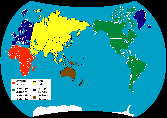
Africa |
|
Continent, largest southward projection of the landmass which constitutes the Old World, surrounded by sea except where Isthmus of Suez joins it to Asia, and extending nearly as far southward of equator as northward. |
|
|
|
|
|
America |
|
Continent of the New World or western hemisphere, consisting of two great land-masses, North America and South America, joined by the narrow isthmus of Central America. |
|
|
|
|
|
Antarctic Antarctica |
|
Regions (both land and sea) round the South Pole. Antarctica: (Antarctic continent) Continent mainly within the Antarctic Circle, almost entirely covered by ice-sheet. |
|
|
|
|
|
Asia |
|
Continent of North hemisphere, East part of the great land-mass formed by the Old World; separated from Europe by the Ural Mountains and the Caspian Sea. Indies: India and adjacent regions and islands; the East Indies; the West Indies. |
|
|
|
|
|
Europe |
|
Continent of North hemisphere, western part of the land-mass of the Old World, bordering on the Atlantic Ocean. |
|
|
|
|
|
Oceania |
|
Islands of the Pacific Ocean and adjacent seas, sometimes including Australasia and Malaysia. AUSTRALIA: Continent of South hemisphere in the South West Pacific with the Tasman Island (Tasmania). MELANESIA: General term for islands of West Pacific including New Hebrides, New Caledonia. Fiji,... MICRONESIA: Division of Oceania comprising the small North West Pacific islands including the Mariana, Caroline, Marshall, and Gilbert Islands. POLYNESIA: General name for all islands in central and West Pacific or for the easternmost of the three great groups of these islands, including New Zealand, Hawaii, the Marquesas, and Samoa. AUSTRALASIA: Term used loosely to include Australia and the islands scattered over the South West Pacific. |
|
|
|
|
|
|
|
|
|
Antarctic |
|
Regions (both land and sea) round the South Pole. The southern reaches of the Atlantic, Pacific and Indian oceans are often considered a single entity. This vast "Southern Ocean" encircles the Antarctic continent with two counter-rotating sets of currents. Hugging Antarctica and streaming from east to west is the so-called East Wind Drift. Farther north, the eastward-directed Antarctic Circumpolar Current prevails. |
|
|
|
|
|
Arctic |
|
Ocean North of the Arctic Circle. The ice-covered Arctic was first recognised to be a deep basin only a century ago, and it remains today the most enigmatic ocean on the earth. Polar Oceans (Antarctic & Arctic): Area: 14 090 000 km2 Average Depth: 988 meters Maximum Depth: 5 502 meters |
|
|
|
|
|
Atlantic |
|
Great ocean lying between Europe and Africa on East and America on West. The Atlantic Ocean is named for Atlas, who according to Homeric myth held heaven up with great pillars that rose from the sea somewhere beyond the western horizon. The Mid-Atlantic Ridge, which runs down the middle of this basin, marks the location of tectonic spreading, where frequent volcanic eruptions continually build up oceanic crust. Area: 82 440 000 km2 Average Depth: 3 330 meters Maximum Depth: 8 380 meters Gulf Stream: Great oceanic current of warm water flowing from Gulf of Mexico parallel with American coast to Newfoundland, and thence (under the name of North Atlantic Drift) towards Europe and round the British Isles. |
|
|
|
|
|
Indian |
|
Ocean to South of India, extending from East coast of Africa to Malay Archipelago. Unlike the Atlantic or Pacific, the Indian Ocean is completely enclosed on the northern side, a configuration that gives rise to drastic seasonal changes in the winds and currents. These monsoons, a variation on the Arabic word mausim, meaning "season", carry moisture northward from the southern Indian Ocean (causing torrential rains to lash India) during much of the summer there. These winds induce a distinctive set of currents in summer. From May through September, shallow currents driven by winds coming from the southwest veer away from the Arabian coast, causing nutrient-rich waters from greater depth to rise to the surface. During the northeast monsoon, which runs from November to March, the surface currents travel in the opposite direction, preventing such up welling of nutrient-rich water. Area: 73 440 000 km2 Average Depth: 3 890 meters Maximum Depth: 7 450 meters |
|
|
|
|
|
Pacific |
|
Largest body of water on earth's surface bounded by North and South America and Asia and Australia. Named by Portuguese explorer Ferdinand Magellan, who believed it to be free of violent storms, the Pacific Ocean is not, in fact, so pacific. Its tropics can be roiled by typhoons, and its shores can feel the brunt of tsunamis (great waves generated by earthquakes). The Pacific is particularly prone to tsunamis because its underlying tectonic plates continually push under adjacent continents and seas at subduction zones. These collisions are marked by oceanic trenches such as the Mariana Trench, which includes the deepest spot on the earth. Area: 165 250 000 km2 Average Depth: 4 280 meters Maximum Depth: 11 034 meters |
|
|
|
|