
Guinea pictures / Photos de la Guinée - p. 1-5
|
|
|
|
|
|
|
|
|
|
|
|
|
|
|
|
|
|
|
|
In April-May 1997, a mission was carried out to evaluate the gold potential of four zones within the Heremakono property, Republic of Guinea, on behalf of Chalice Mining inc. This Canadian company has recently obtained an option to acquire a part of the interests of Patrician Gold Mines in the Heremakono property. This property covers 250 km2 in northeastern Guinea, some 570 kilometers east-northeast of the capital city Conakry. The objective of the mission was to sample four square zones (2 km N-S by 2 km E-W) centered on four gold digging sites identified during a previous mission, in April 1996. A total of 513 soil samples were collected in the four zones, on a regular 200 X 200 meters grid. Coordinates (latitude, longitude), altitude and soil description were noted at each sampling site. The samples were sent to the Intertek Testing Services laboratory in Mandiana for gold analysis.
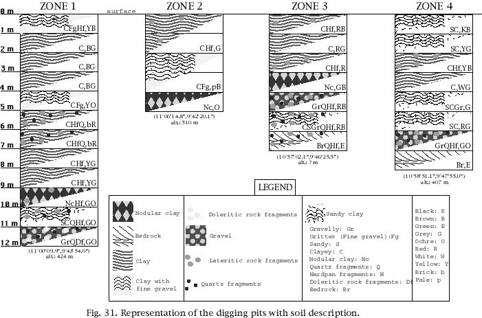
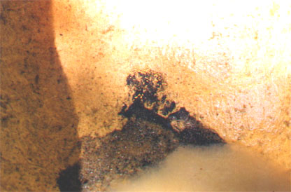
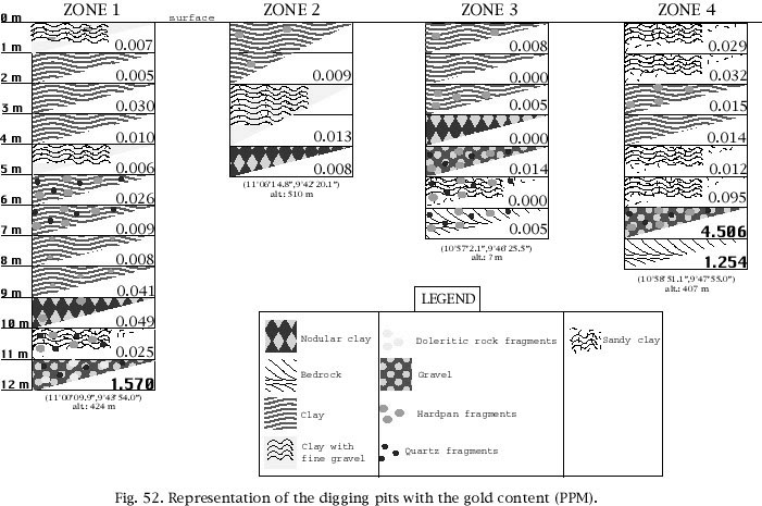
The four zones appear to be overlain by Birrimian greenstones, with a large dolerite intrusion in the central part of the permit. In addition to the soil samples, which were collected at a depth of 30-40 cm to avoid contamination from windblown or waterborne material, several gold digging pits were vertically sampled, down to a maximum depth of 12 meters. These gold digging pits always show the same profile, that is clay on surface followed by nodular clay, a gravel horizon and bedrock at the bottom.
Significant gold in soil values (in the range of 191 ppb to 9.99 g/t Au) were encountered in each of the four zones. These encouraging values confirm the auriferous potential of the Heremakono permit and warrant a follow-up program with an estimated budget of 116 630$ for phase I (more accurate delineation of previously identified gold soil anomalies) and 154 780$ for phase II (1 000 meters of reverse circulation drilling for testing the bedrock source of the best geochemical anomalies).
En avril-mai 1997, une mission a été organisée dans le but d'évaluer le potentiel en or de quatre zones à l'intérieur de la propriété d'Heremakono, République de Guinée, pour Chalice Mining inc. Cette compagnie canadienne a récemment obtenu une option pour acquérir une partie des intérêts de la propriété d'Heremakono appartenant à Patrician Gold Mines. Cette propriété, qui couvre 250 km2, est située dans le nord-est de la Guinée à environ 570 kilomètres à l'Est-Nord-Est de la capitale Conaky. L'objectif de cette mission était d'échantillonner quatre zones carrées (2 km N-S par 2 km Est-Ouest) centrées sur quatre sites d'excavation aurifères identifiés durant une mission antérieure, en avril 1996. Un total de 513 échantillons de sol a été recueilli dans les quatre zones, sur une grille régulière de 200 x 200 mètres. Les coordonnées (latitude, longitude), altitude et description du sol ont été décris dans chacun des sites échantillonnés. Les échantillons ont été envoyés au laboratoire Intertek Testing Services à Mandiana pour être analysés en or.
Les quatre zones sont recouvertes par des roches vertes (greenstones) du Birrimien, avec une large intrusion de dolérite dans la partie centrale du permis. En plus des échantillons de sol, lesquels ont été obtenus à une profondeur de 30-40 cm pour éviter qu'ils aient été contaminés par du matériel transporté par le vent ou l'eau, plusieurs puits d'excavation d'or, d'une profondeur maximale de douze mètres, ont été échantillonnés verticalement. Ces puits d'excavation d'or montrent toujours le même profil, soit de l'argile en surface suivie d'argile nodulaire, un horizon de gravier et un socle rocheux au fond.
Une quantité significative d'or dans le sol (variant de 191 ppb à 9,99 g/t Au) a été notée dans chacune des quatre zones. Ces valeurs encourageantes confirment le potentiel aurifère du permis à Heremakono et garantissent un programme de poursuite avec un budget estimé à 116 630 $ pour la phase I (description plus précise des anomalies en or de sol précédemment identifiées) et 154 780 $ pour la phase II (1 000 mètres de forage à circulation inverse pour tester les meilleures anomalies géochimiques de la source du socle rocheux).
|
|
| |
|
|
|
|
|
|
| |
|
|
|
|
|
| ||
|
|
| |
|
|
|
|
|
|
| |
|
|
|
|
|
| ||
|
|
| |
|
|
|
|
|
|
| |
|
|
|
|
|
|
| |
|
|
|
|
|
|
| |
|
|
| |
|
| ||
|
|
| |
|
|
| |
|
| ||
|
|
| |
|
|
| |
|
|
| |
|
| ||
|
|
| |
|
|
| |
|
|
|
|
|
| ||
|
|
| |
|
|
| |
|
|
| |
|
|
| |
|
|
| |
|
|
|
|
|
|
| |
|
|
|
|
|
|
| |
|
|
|
|
|
|
| |
|
|
|
|
|
|
| |
|
|
|
|
|
|
| |
|
|
|
|
|
Ministerial decree granting the exploration permit |
| |
|
|
|
|
|
Summary of fire assay method and some other methods used by the ITS laboratory in Mandiana |
| |
|
|
|
|
|
Analytical results |
| |
|
|
|
|
|
Description of soil samples and of samples collected in the gold digging pits, by numerical order |
| |
|
|
|
|
|
UTM coordinates for all the samples collected during the April - May 1997 mission |
|
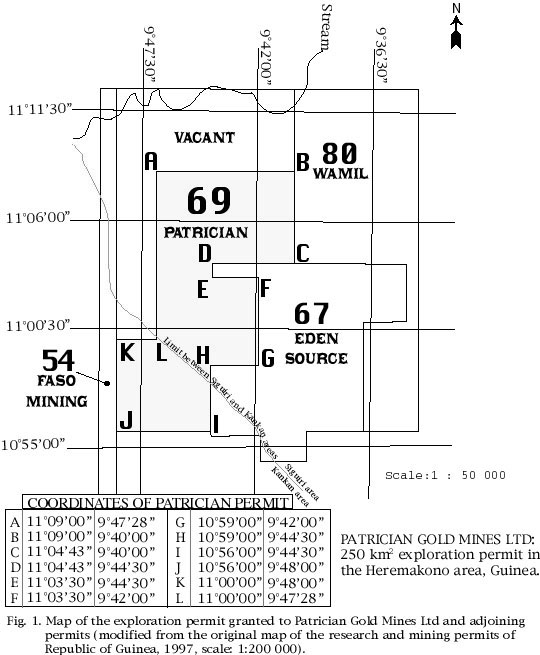
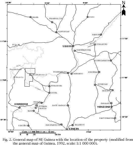
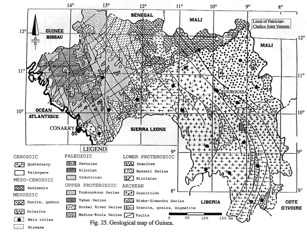
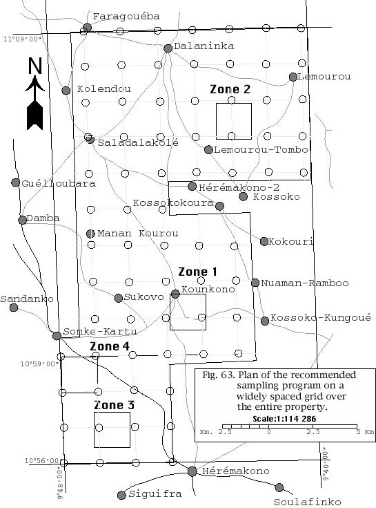
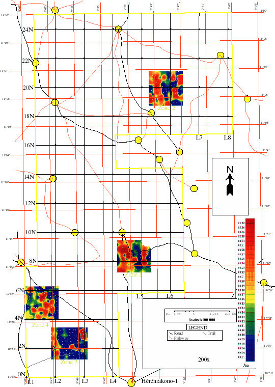
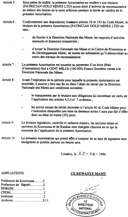
Following the positive results of a reconnaissance mission carried out in 1996, partners Patrician Gold Mines Ltd and Chalice Mining Inc. applied for an exploration permit in the Heremakono area, Guinea. The permit was granted by the Ministry of Mines and Geology of Guinea in August 1996 (see copy of ministerial decree in appendix I: page 1 and page 2). The limits of this 250 square kilometers permit are shown on figure 1, while figure 2 shows its location in the northeastern part of Guinea. Chalice Mining Inc, a Canadian company having its head office in Vancouver, has recently obtained an option to acquire an additional interest from Patrician Gold Mines in the Heremakono property.
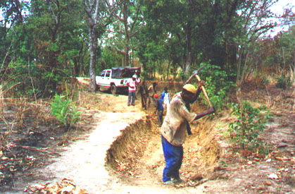
The exploration permit is located near Heremakono-1, about 570 kilometers east-northeast of Conakry, the capital city of Guinea (figure 3). From Kouroussa, some 50 km to the SW, the property is accessible by two sides. The first side, in direction of Boroto, is the shortest way to reach the property, but the road is not permanently practicable, whereas on the other side, in direction of Balato, the road is permanently practicable. However, the adjective practicable doesn't mean that the road is in good condition, and many segments of roads had to be fixed before they could be used by a 4 X 4 truck (figure 4: Sometimes, the roads were impracticable, and had to be repaired). Figure 5 shows the main roads in the permit area.
Before leaving for Heremakono, some tools and camping equipment were bought in Conakry (figure 6: A market in Conakry). In Conakry, visits were made to the "Direction Nationale des Mines et de la Géologie" (DNMG; Mr Ce Kewanye Mamy, director) and to the "Centre de Promotion pour le Développement Minier" (CPDM, Mr Morciré Sylla, director), to inform the governmental authorities about the work to be undertaken by Chalice Mining on the Heremakono permit.
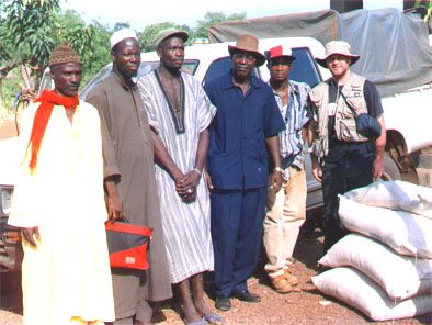
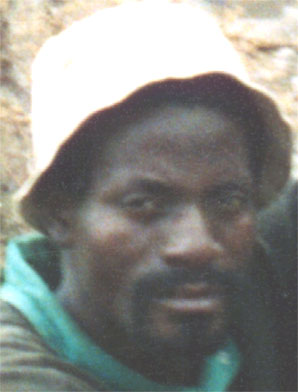
Before initiating the field work, it was also necessary to obtain the approval from the local authorities in Kouroussa and Heremakono (figure 7: From left to right: two councillors of Heremakono, the mayor of Heremakono, the sub-prefect of the Siguiri area, the driver and Serge Fortin). In respect towards the natives traditions, a distinct authorization had to be obtained from the chief of each village, but this never caused any problem since the populations behaved in a very friendly way.
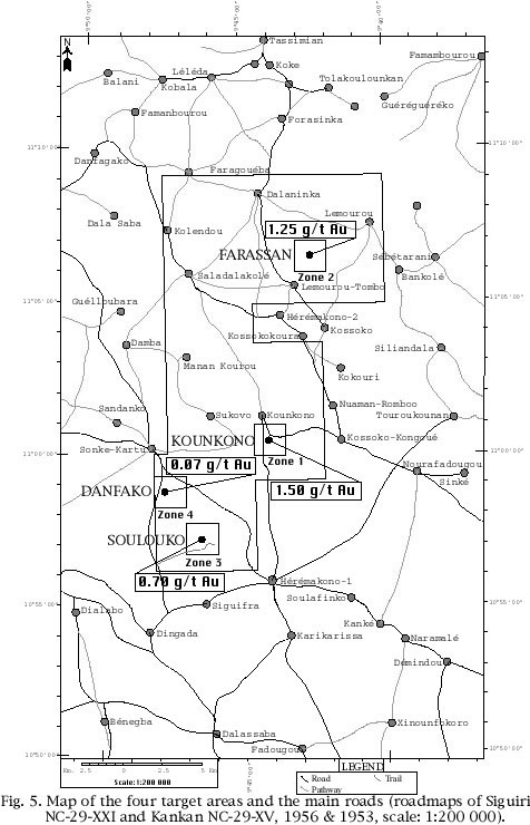
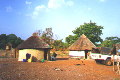
The village of Heremakono was chosen as the site for the base camp, because of its proximity to three of the four target areas (figure 5). The mayor of the village provided some huts that were used by the field crew during the mission (figure 8: The team lived in three huts in the Heremakono village and figure 9: The hut to the right was used for showering. In the background is the Heremakono village).
The objectives of the April 1997 campaign were as follows:
Four gold digging sites that had been identified within the limits of the permit during a previous mission (Plouffe, 1996) were selected as target areas for soil geochemical sampling (figure 5). These four sites were classified in decreasing order of priority as follows, based on the analytical results from samples collected during the first mission:
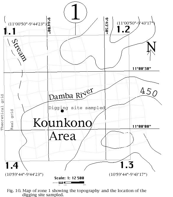
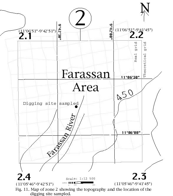
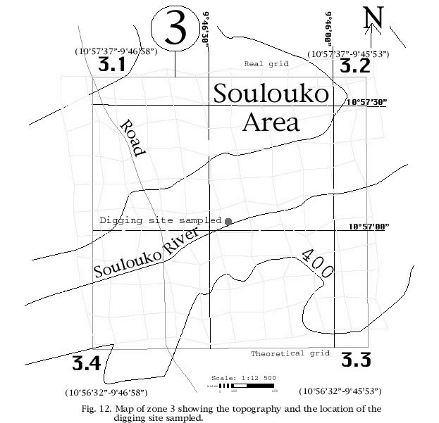
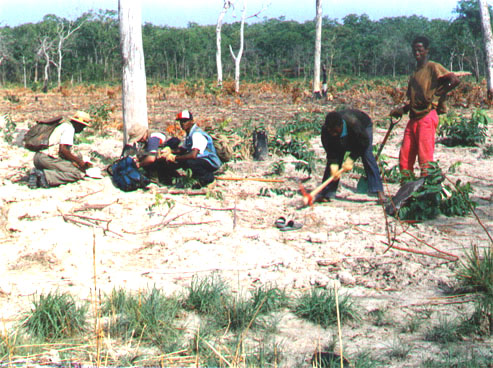
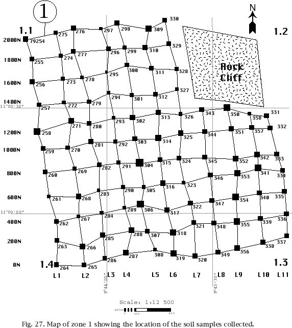
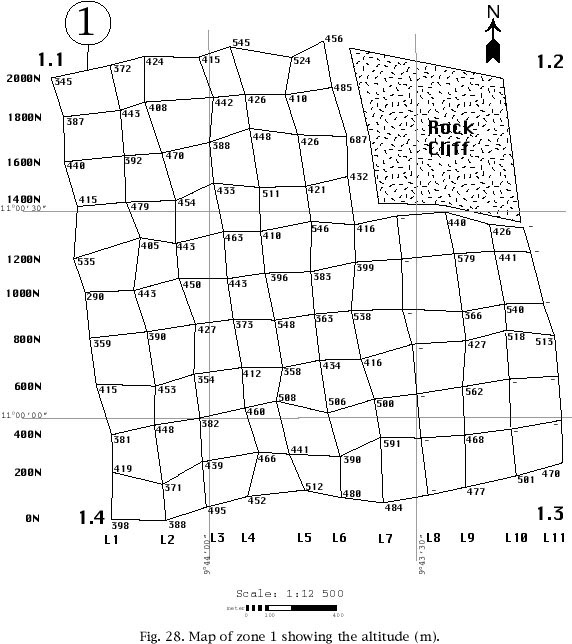
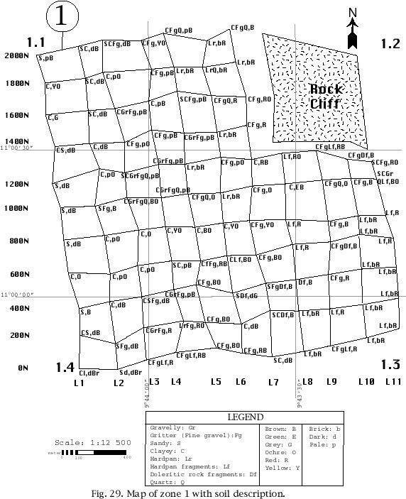
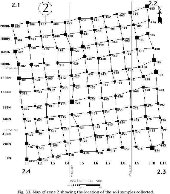
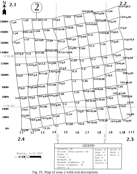
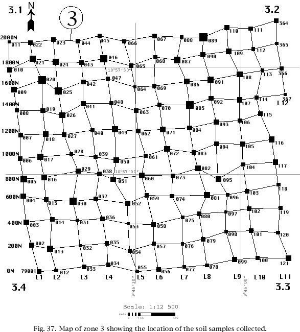
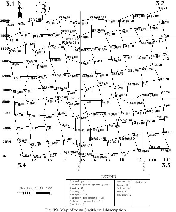
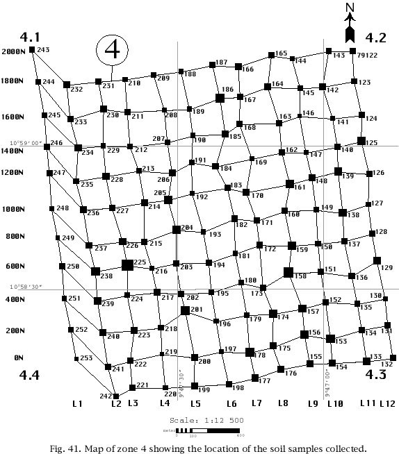
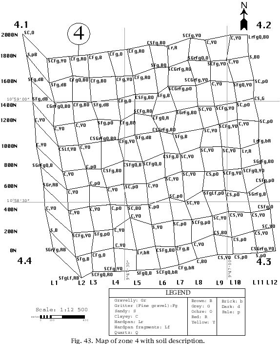
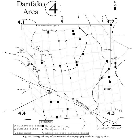
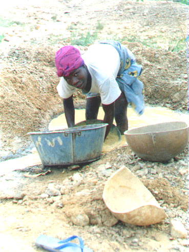
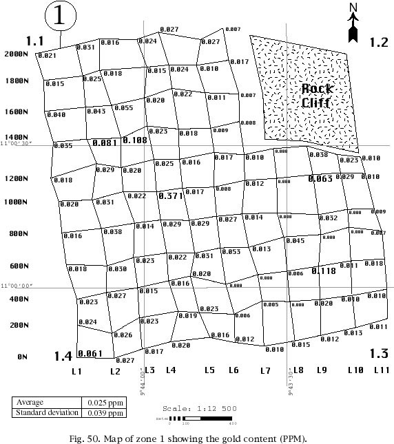
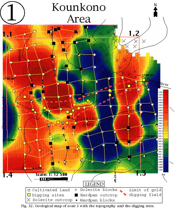
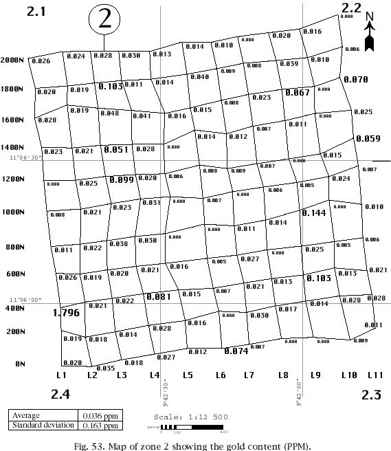
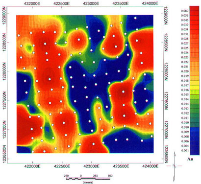
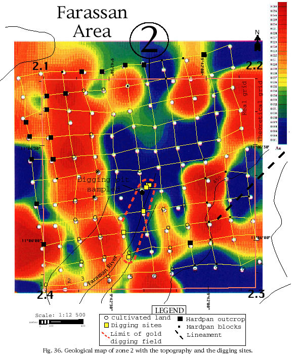
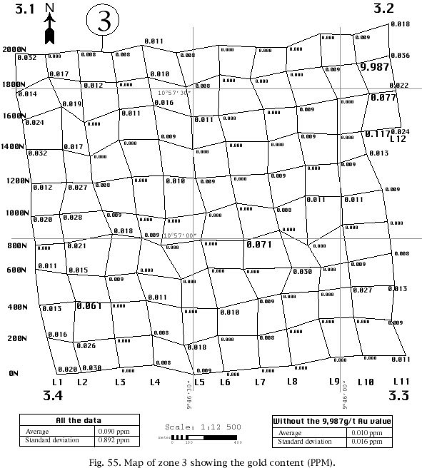
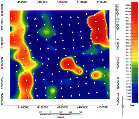
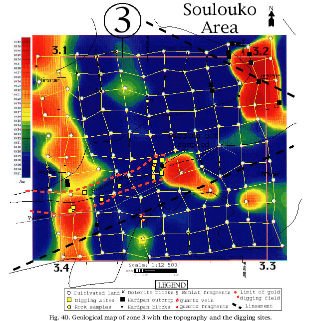
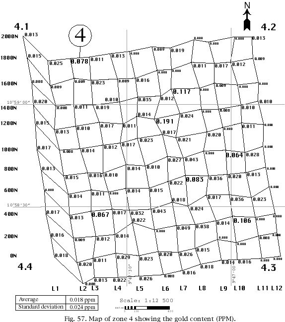
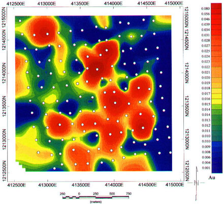
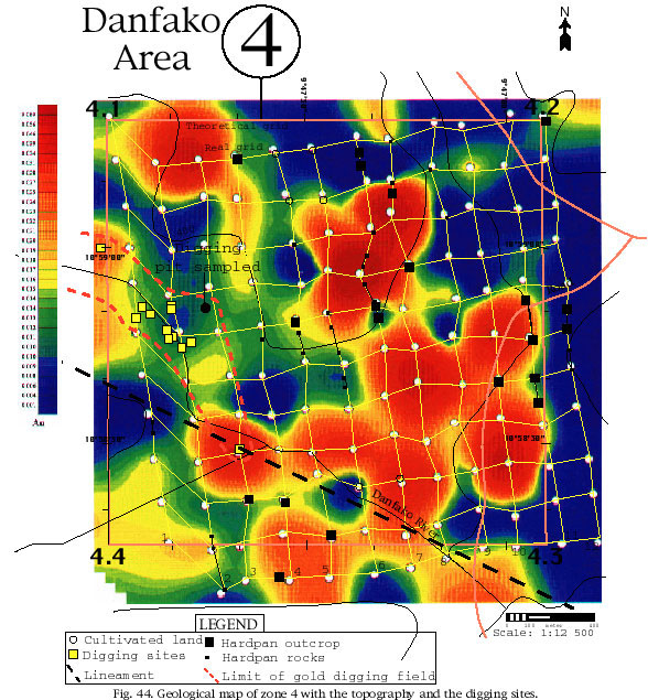
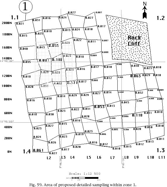
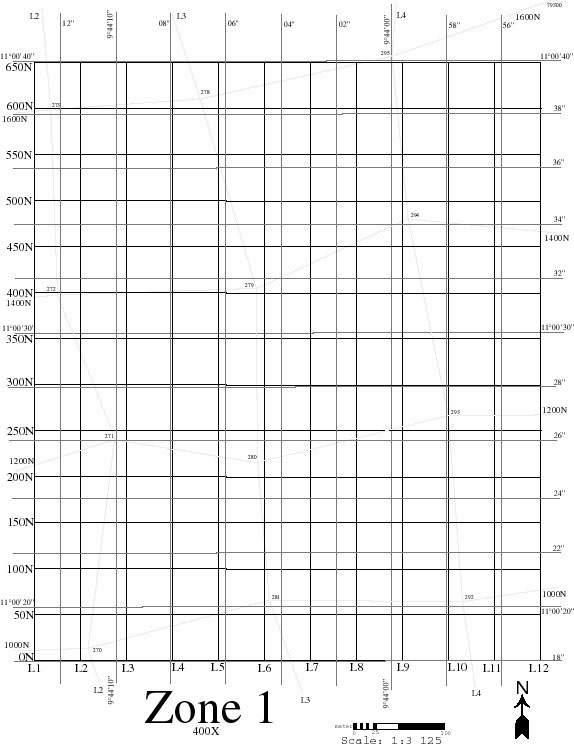
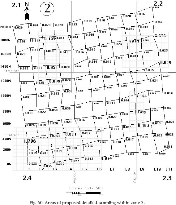
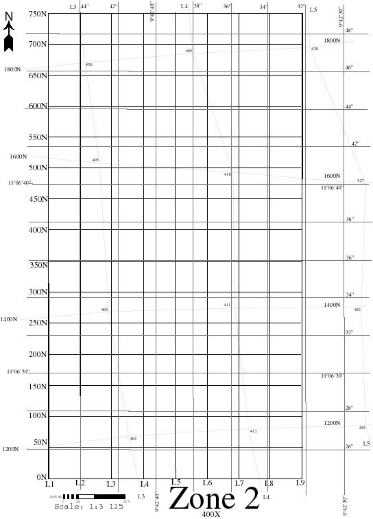
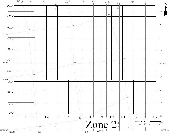
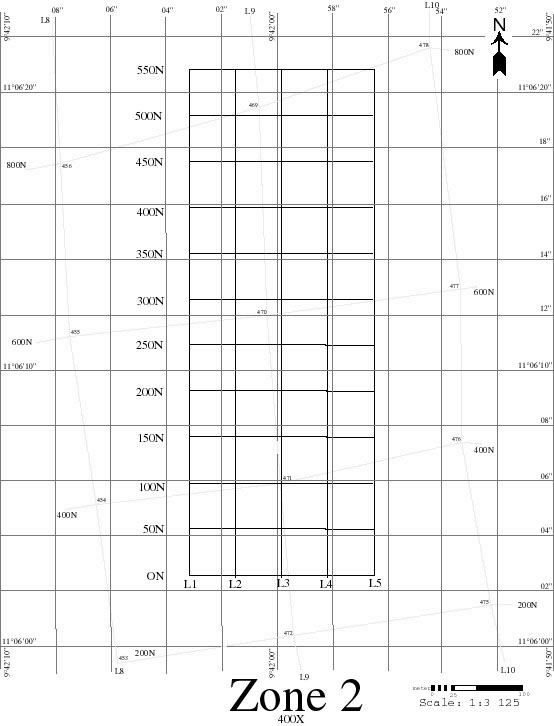
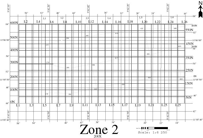
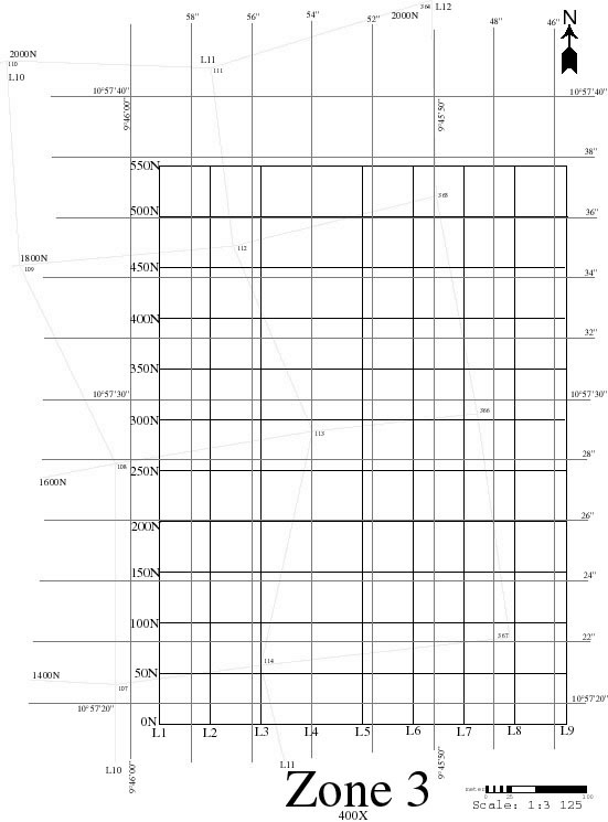
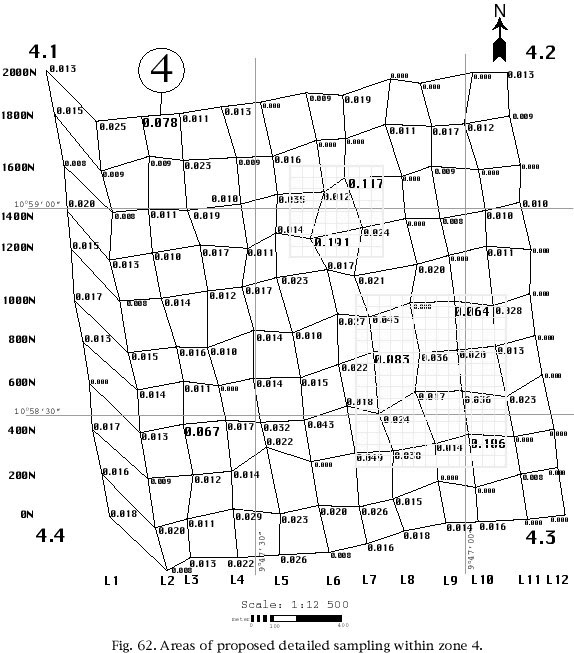
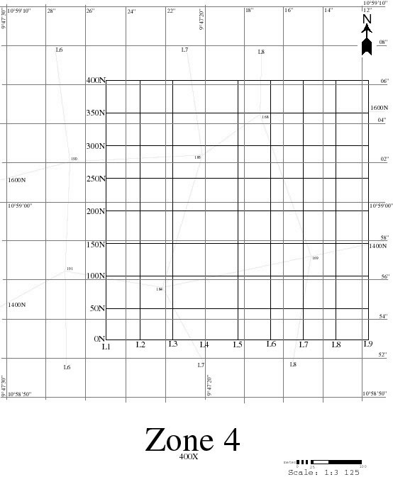
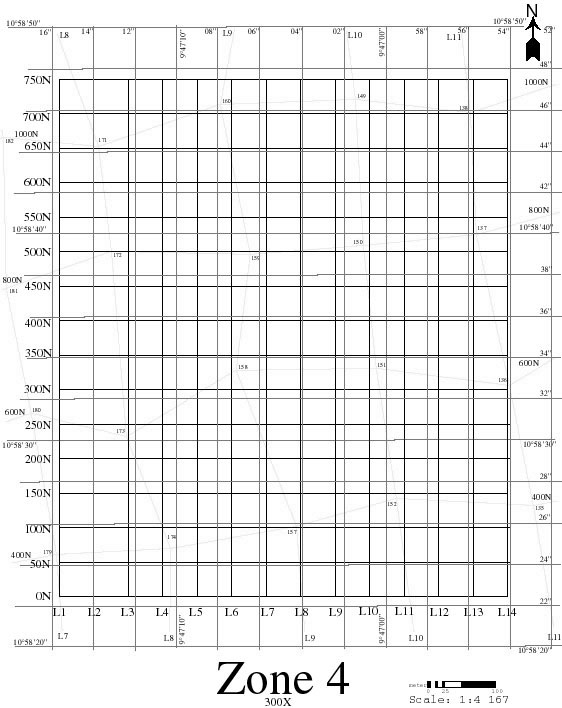
A zone measuring 2 X 2 km was defined around each of the identified gold digging site (zones 1 to 4, figure 5). These zones were to be sampled on a 200 X 200 m grid, for a total of 121 soil samples in each zone. The samples were systematically collected at a depth of 30 cm, in order to represent the in situ laterite formed by the weathering of the underlying bedrock, and not surficial material transported by wind or water during the seasonal periods of flooding. The only exception to this procedure is where hardpan (or duricrust) is present on surface. In these cases, the hardpan was directly sampled, as it constitutes an integral part of the lateritic profile and known to preserve the geochemical signature of its bedrock source.
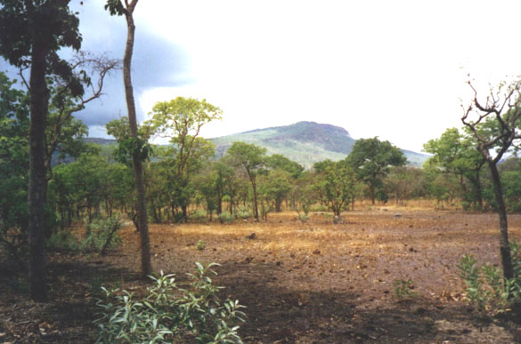
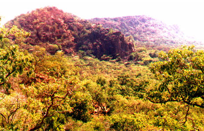
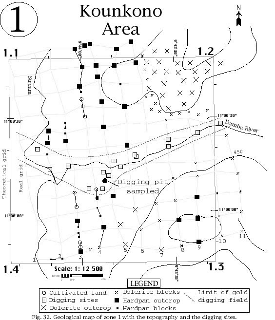
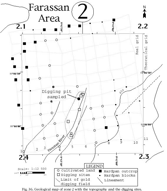
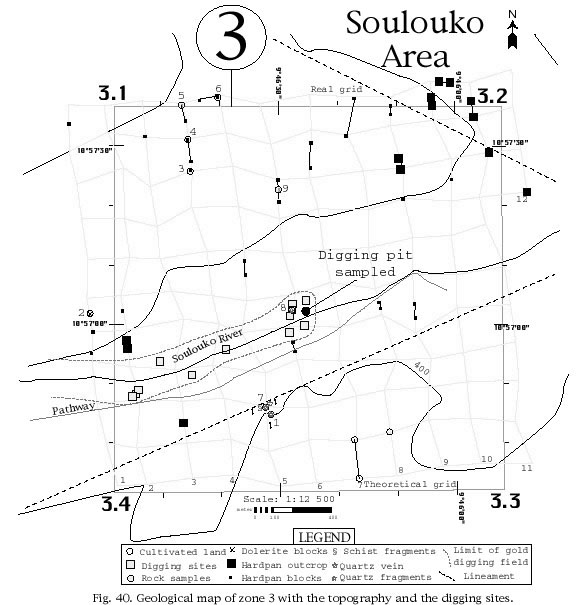
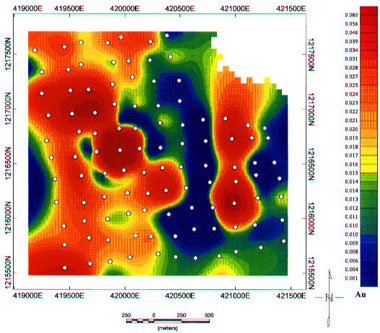
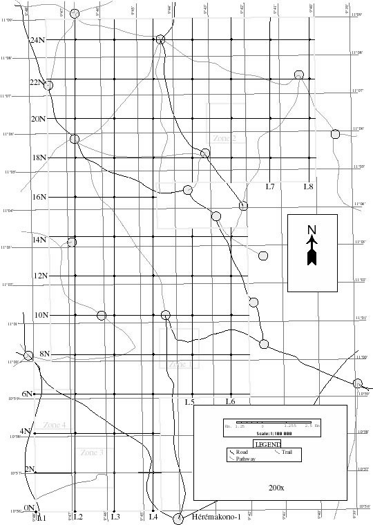
Figure 10, figure 11, figure 12 and figure 13 show the theoretical grid drawn on the map versus the real grid sampled in the field, based on the positions provided by the GPS (Global Positioning System). Of course, the real grid is more erratic due to the forested and hilly nature of the terrain (figure 14: In zone 1, there are many hills like this one (L11 - 0N), figure 15: In zone 1, there is a big rock cliff (L8 to L11 - 1400N to 2000N) that prevented soil sampling in that sector and figure 16: Closer view of the cliff shown on figure 15), and also because of small deviations of the compass due to local differences in the magnetism of the geological formations.
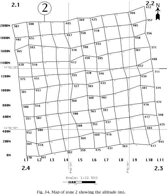
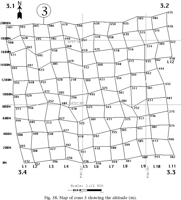
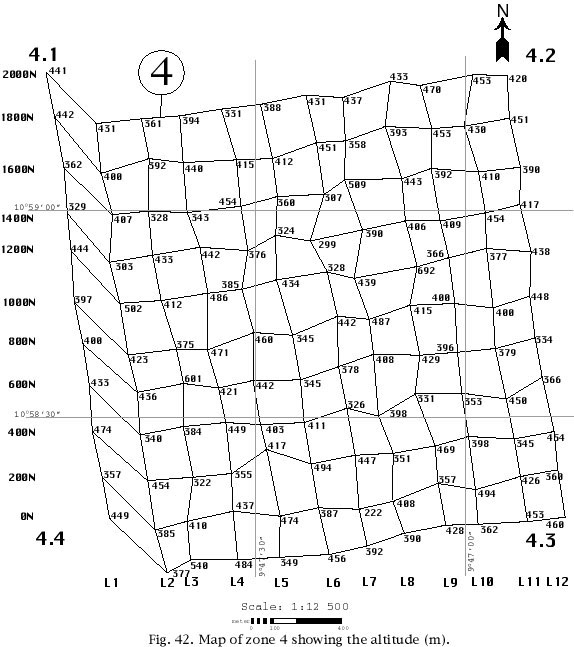
The GPS device used was a model 12 X L from GARMIN. This instrument gives the exact location of a site (longitude and latitude) with an accuracy of ± 15 meters. It also gives the altitude, but this measure is less accurate (frequently 30 to 60 meters off) and therefore has only an indicative value.
A typical soil sample was taken as follows:
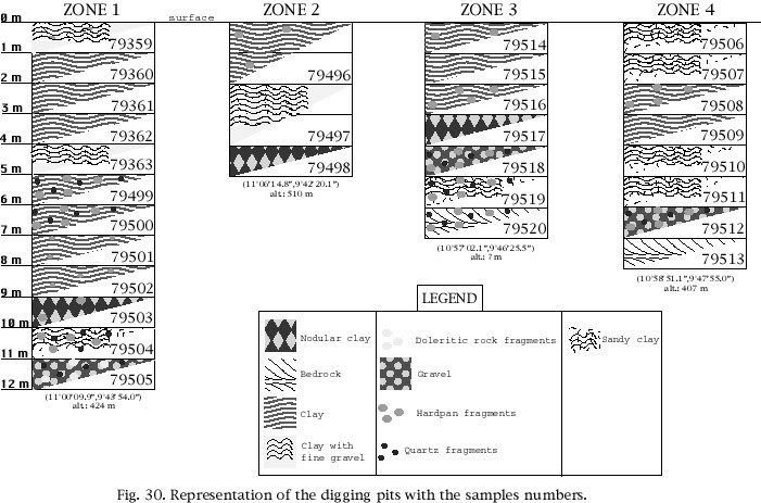
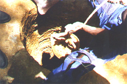
In each of the four target zones, one of the deepest gold digging pit was sampled, in order to gain a better knowledge of the vertical variation of the gold concentration within the lateritic profile. The location of the four pits selected for sampling is shown on figure 10, figure 11, figure 12 and figure 13.
A typical pit sample was taken as follows:
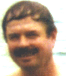
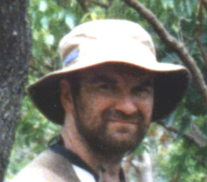
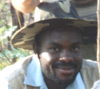
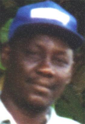
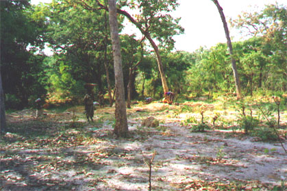
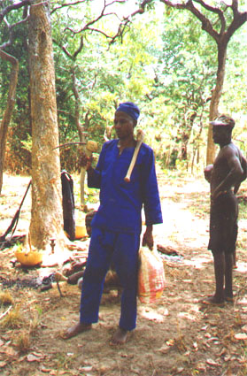
The field work was carried out using a four-wheel drive Toyota truck (figure 8) rented from a private owner. Pierre Trudel, who was working on another project in Guinea, acted as supervisor of this mission (figure 21). Serge Fortin and Yves Nata were the Canadian geologists and Maurice Dopaogui from the Ministry of Mines and Geology, was their Guinean counterpart and interpreter (Malinké is the native language spoken in this part of Guinea). Barry Thierno Sadou proved to be a good driver and a very motivated worker in the field. The two Guinean workers (Moussa and Kalil) were exemplary by the quality of their work and their motivation to make the mission successful. Alpha Kabiné Magassouba, the logistics manager of the mission, was very important particularly in the beginning of the mission. Overall, the field team was very dynamic and motivated.
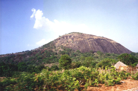
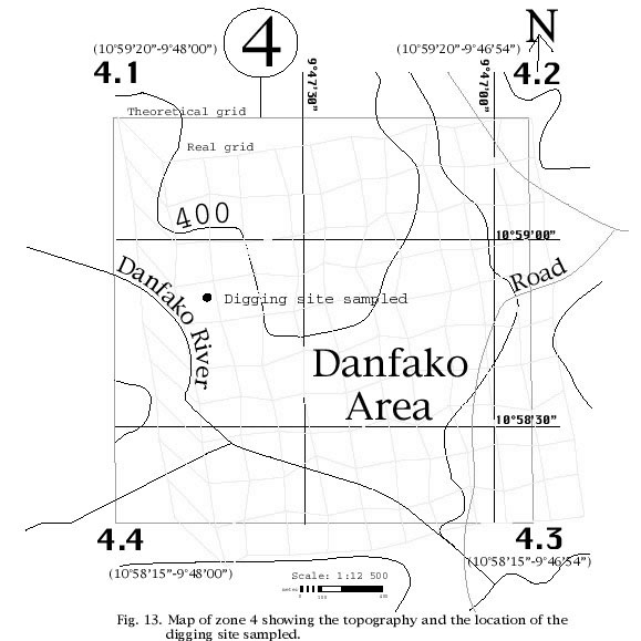
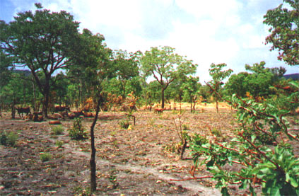
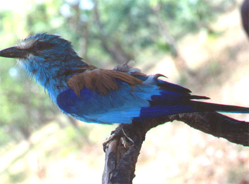
The four target areas are relatively hilly and heavily to poorly forested. The vegetation type varies from forest on the hills to savanna in the plains. The fauna is diversified. Antelopes, monkeys and warthogs were observed as well as a wide variety of birds (figure 22: In the different zones, there are some beautiful animals like this blue bird).
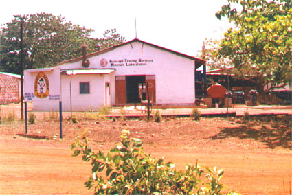
The materials collected for geochemical analysis consisted of soil samples, lateritic material (hardpan) and some rock samples. All the samples collected weighted around one kilogram and were sent to the Intertek Testing Services (ITS) Laboratory in Mandiana (figure 23: ITS laboratory in Mandiana) some 120 kilometers (in straight line) to the southeast of Heremakono (figure 2).
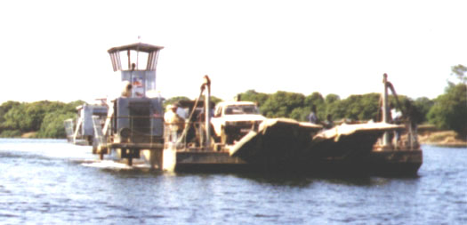
To reach Mandiana, it is necessary to cross the Niger river with a ferryboat (figure 24: Ferryboat on the Niger river used to go to Mandiana). All the samples were analyzed for their gold content by fire assay. In the beginning, the FA30 option was used, but at the end, this option was changed for the FA50 option. The only difference between these two options is the amount of material used for fire assay. For the FA30 option, the laboratory uses 30g of material while for the FA50 option, it uses 50g of material. The FA30 option has an accuracy of ±0.008 ppm (or 8 ppb), while the FA50 option has an accuracy of ±0.005 ppm (or 5 ppb). The FA50 option is therefore more representative of the true gold content of the sample, being carried out on a larger sample. It is however somewhat more expensive than the FA30 option (7,90 $ US per analysis versus 7,20 $ US).
The detailed description of the analytical procedures used by ITS for gold determination by fire assay is given in appendix II. The complete analytical results are presented in appendix III, while the description of all the samples collected is given in appendix IV.
Hubert and Goloubinow were the first geologists to study the Siguiri-Kankan-Kouroussa area. Hubert, in 1912, was the first one to publish an interpretation of the geology of the Siguiri-Kankan-Kouroussa area (Delbos and Normand, 1983). He identified the Birrimian (Lower Proterozoic) formations composed of subvertical schists and quartzites. Goloubinow mapped the Siguiri-Kankan-Kouroussa area between 1931 and 1937 and published his final report in 1950. He was the first one to distinguish between the Liberian granites of Archean age and the Eburnean granites of Birrimian age. He found a prospective zone of alluvial gold in the Dingdingkoli stream and a second zone of lesser importance in a segment of the Lélé river. His work in this area is summarized in the BRGM-Guinée synthesis report, 1975.
After the independence of Guinea, Techno-Export, a Soviet cooperation mission, produced a schematic tectonic map of Guinea (Garachtchouk et al., 1963). The Soviet team also produced a synthesis report on gold and diamond occurrences in eastern and northeastern Guinea. A geological interpretation of Landsat images with a 1:1000000 scale map was also produced by Geosurvey International (1975).
In 1979, a West German society, with an office in London, carried out a survey including air photographs, airborne geophysics and Landsat photo interpretation that covered the whole country of Guinea at the 1:30 000 scale with a 1 km survey lines spacing. The Kankan-Kouroussa area was covered and the magnetic map clearly showed some geological distinctions within the Birrimian series which were not indicated on the 1:500 000 geological map of the area (Delbos and Normand, 1983). Unfortunately, because of a payment problem, the German society only submitted a preliminary report and the geophysical maps have not been released yet.
In April-May 1996, a reconnaissance was carried out in the Heremakono area, under the leadership of Christian Plouffe, a consultant geologist from Montreal (Plouffe, 1996). The reconnaissance zone granted by the Guinean government to the Patrician-Chalice joint venture measured 482 km2 (figure 3). This zone is overlain by supracrustal rocks of Birrimian (Lower Proterozoic) age consisting of a lower sequence of mica-schists and an upper sequence of volcanic rocks, both composing the Siguiri Basin. These supracrustal rocks are intruded by a large mass of dolerite in the west central part of the reconnaissance zone.
Gold is found in various environments and occurs in two deposit types in the Siguiri Basin: secondary gold (placer) and primary gold deposits (lode). The placer gold, which is of alluvial origin, occurs extensively in the vicinity of the reconnaissance zone. This type of gold occurs in two main areas: the Kossoko river basin and its auriferous tributaries (northern portion), and the Manan Kourou area (to the south) and its associated auriferous draining rivers. Plouffe (1996) reports: "The Manan Kourou area is a vast zone of outcropping dolerite with schistose saprolite of sedimentary or igneous origin. Rock foliation is polyphased and the strongest schistosity is oriented about north-south." Both lode gold deposits and gold placers are located along a regional auriferous fault zone that crosscuts the reconnaissance zone. Based on the analytical results from samples collected in the gold digging areas, Plouffe (1996) concluded that the reconnaissance zone was very favorable for finding commercially exploitable gold deposits.
Consequently, an application was filed by Patrician Gold Mines in order to turn the reconnaissance zone into an exploration permit. Such a permit, measuring 250 km2, was granted to Patrician by the Guinean government in April 1996 (see appendix I and figure 1). This permit, however, includes only four of the seven gold digging sites identified by Plouffe (1996).
In early 1997, Chalice Mining reached an agreement with Patrician Gold Mines to increase its interest in the Heremakono exploration permit.
According to the geological map of Guinea (figure 25), the Heremakono permit is entirely overlain by supracrustal rocks of Birrimian age. These Birrimian formations are composed of a lower sequence of mica-schists overlain by an upper sequence of volcanic rocks, laid down in an extensive geosyncline known as the Siguiri Basin.
This succession is cut by many quartz veins and some dolerite dykes and plugs (figure 26). The basin is subdivided into different belts separated by granites. There is a lot of mylonitization, migmatization and granitization. Limestone, transformed into marble, has been recorded in several places as xenoliths in granites. These Birrimian belts are of similar age and composition as those which host many West African gold deposits including Ashanti and Bibiani in Ghana; Syama, Sadiola, Kalana and Loulo in Mali, and Afema in Ivory Coast (Milesi et al., 1989).
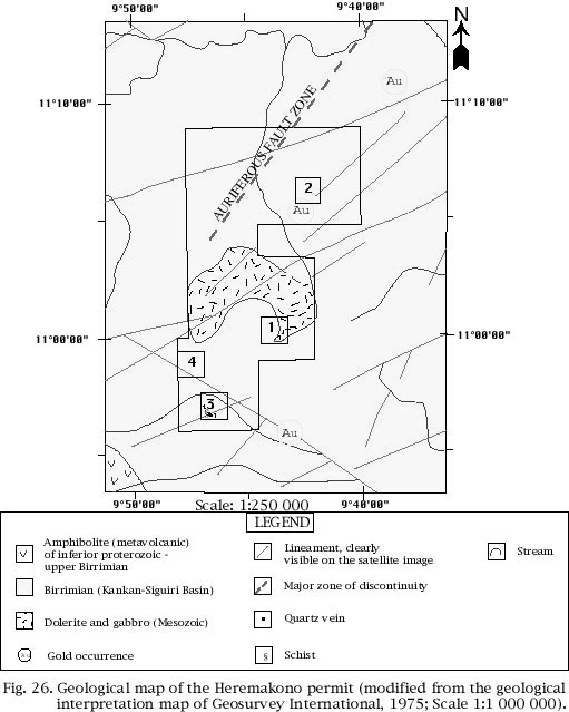
Figure 26 shows the geological map of the Heremakono permit, as interpreted from the satellite images (Geosurvey International, 1975). According to this interpretation, the permit is entirely overlain by the volcano-sedimentary rocks of the Siguiri Basin, except for a large doleritic intrusion in its central part. This map also shows that:
|
|
P.S.: Tu use this article, you must have the permission of SIDAM. Someone who use this article in an excessive way can be prosecuted by SIDAM Thank you for your understanding.
|
|
|
|